19-Mile Impact Crater Found In Greenland May Confirm Great Flood
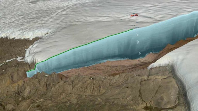
A 19-mile wide impact crater was discovered half a mile beneath a Greenland ice sheet, offering scientists and archeologists proof that a mile-wide meteorite impacted the planet’s northern ice cap more than 12,000 years ago.
The discovery appears to support a contentious theory proposed by researchers, including Graham Hancock and Dr. Robert Schoch, who believe such a cataclysmic impact may have wiped out a lost civilization that predated the accepted timeline of mainstream archeology.
“You have to go back 40 million years to find a crater of the same size, so this is a rare, rare occurrence in Earth’s history,” Kurt Kjær, of the Natural History Museum of Denmark in Copenhagen, told The Guardian.
According to researchers involved in the study, the asteroid impacted an area known as the Hiawatha glacier, on the northwestern side of Greenland. Traveling at a speed of 12 miles per second, the iron space rock slammed into Earth with the force of about 47 million times the energy released by Little Boy, the nuclear bomb dropped on Hiroshima during WWII. The meteorite ranks within the top 25 largest meteorites to ever have impacted Earth.
The force of the impact would have melted large amounts of ice, causing sea levels to rise, and debris to be catapulted high into the air. This dust and detritus would have resulted in a nuclear winter, leaving heavy particulate matter hanging in the atmosphere for hundreds of years, before settling and allowing sunlight to reach the planet’s surface again.
Early evidence of such an impact was found in 2015 when scientists noticed that ice samples taken from the glacier showed signs of an impact. Unsurprisingly, around this time temperatures dropped abnormally following the end of the last ice age, throwing Earth’s climate back into an even more severe ice age known as the Younger Dryas.
But before finding evidence of such a cataclysmic event, scientists were unsure of what could have caused the drastic swing in temperature.
“Archeologists tend to be uniformitarians, they don’t really like cataclysms very much,” Hancock said. “And they don’t, in my view, take enough account of the role of cataclysmic events in the story of human civilization.”
Years before this data became apparent, Hancock proposed a cataclysmic event much like this, believing it could explain anomalous evidence of an ancient civilization predating the Egyptians and Sumerians by thousands of years. The theory, known as the Younger Dryas Impact Hypothesis, supported the possibility that such an apocalyptic event could provide evidence for the existence of a lost civilization, such as Atlantis.
According to Hancock, the dust launched into the atmosphere from the asteroid’s impact likely lingered for as long as 1,600 years before temperatures began to rise. This led to massive amounts of melted ice as the cold subsided, which in turn caused sea levels to rise.
This period of around 11,600 years ago, corresponds almost exactly with the period Plato mentions as the era in which Atlantis was destroyed.
“Plato said Atlantis was destroyed by a giant flood and earthquakes 9,000 years before the time of Solon (an Athenian statesmen). Solon is 600 BC, so that’s 9,600 BC, which is 11,600 years ago – that is the end of the Younger Dryas. How could Plato have made that up?”
For more on Graham Hancock’s Younger Dryas Impact Hypothesis watch this episode of Disclosure :
Amateur Historian Finds Ancient City & Discovery Changes Human Timeline

The timeline of history changes again, as new evidence pushes the oldest known Homo sapiens in Africa back thousands of years.
In southwestern Ethiopia, a mystery nearly a quarter of a million years in the making has been solved. Homo sapien remains found near the Omo river, dubbed “Omo 1,” were originally found in the 1960s. Scientists struggled for years to establish a date for these remains, but in 2005 they determined Omo was approximately 195,000 years old.
Now, a new study by volcanologist Dr. Celine Vidal of Cambridge University pushes that date much farther back by more than 30,000 years, which places modern humans in eastern Africa more than 230,000 years ago.
Vidal was able to determine this by comparing the thick layers of ash left by an ancient volcano from the top of the remains of Omo 1 with ash known to be from a volcano that erupted about 230,000 years ago. Now that the minimum date for Homo sapiens in eastern Africa has been established, researchers are searching for the maximum.
As, Christine Lane, a co-author of the study stated, “[I]t’s possible that new finds and new studies may extend the age of our species even further back in time.”


