Deeper Space: Episode 1

Episode 1: Ancient Space Program
Ancient civilizations inspire wonder, curiosity and questions about the origins of humanity. Many ancient sites, often found on ley lines, have mysterious and advanced infrastructure, architecture and technology that history and archaeology cannot explain.
Deep Space: A Call to Question History
Explore the mysteries of ancient civilizations and ponder the questions: Can we solve some of today’s most complex problems with the wisdom and technology of ancient civilizations? Is NASA on a covert quest to uncover ancient technologies? What can we learn from the ruins of ancient civilizations that you won’t find in government-sanctioned textbooks? What caused the sudden decline of so many ancient cities? Did the technology of ancient civilizations originate from extraterrestrials?
“I knew that a historian (or a journalist, or anyone telling a story) was forced to choose, out of an infinite number of facts, what to present, what to omit. And that decision inevitably would reflect, whether consciously or not, the interests of the historian.” -Howard Zinn
Rewrite the story of human evolution and find clues to an alternative history in the mysteries of ancient civilizations. Learn more or start watching now.
Ancient Space Program
Since the 1960’s, NASA-born space programs have taken a prominent place in the media and collected accolades for their accomplishments of furthering humanity into the space age. But what if this was all a major front to obscure NASA’s interest in ancient space programs?
WHAT ARE LEY LINES?
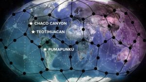
Ley lines, or Dragon Lines, are lines of geological and cultural significance that connect Sacred Sites geographically across the Earth. They are comprised of nodal points on the Earth’s energy grid. While ley lines may have been created due to overland trekking by line-of-sight navigation, they are often aligned with vortices, magnetic fields or underground streams. Is there a more intelligent design behind the placement of sacred sites on Earth?
“If you want to find the secrets of the universe, think in terms of energy, frequency and vibration.” -Nikola Tesla
Chaco Canyon, Teotihuacán and Pumapunku are just a few of the sacred sites that harbor mysterious beginnings and endings – and inspire endless questions, still unanswered. These sites, among many others, are also the focus of archaeoastronomical research on the astronomical knowledge of prehistoric cultures.


Chaco Canyon: The Key to Space Travel?
Chaco Canyon inspires and intrigues archaeologists and stargazers; it has also garnered the attention of NASA. Is this ancient site the potential key to space travel?
CHACO CANYON: THE ANCIENT OBSERVATORY
Chaco Canyon is a shallow, 10-mile canyon is located in a remote and desolate northwest corner of New Mexico that housed an ancient and advanced civilization. Chaco Canyon may have been a distribution center for a large trading network: colorful parrot feathers, copper bells and seashells from up to 3,000 miles (4,800 km) away have been found in the ruins. Yet, the sudden decline of the people of Chaco Canyon and the construction of this ancient observatory remain unexplained.
- Location: Chaco Canyon, New Mexico, United States
- Peak Population: 2,000
- Peak Activity: 900-1150 AD/CE
- Known For: Chacoans quarried sandstone blocks and hauled timber across great distances, assembling fifteen major complexes that remained the largest buildings in North America until the 19th century. They are known for their trade activity, religious ceremonies and knowledge of astronomy
- Decline Began: 1130 AD/CE
- Archaeological Reason for Decline: Drought and lack of resources may have lead to a mass migration into the valleys and drainages of major rivers nearby
ARCHITECTURAL MYSTERY
Original Inhabitants were largely farmers until approximately 800 AD/CE, when they began constructing massive stone buildings Based On Astronomy. Generations of The Ancient Ones, also known as the Anasazi, dedicated themselves to building these pueblos: construction required transportation of sandstone from nearby cliffs and timber hauled from over 50 miles (80 km) away. The pueblos were aligned with the movements of the sun and the 18 ½ year lunar cycle, a feat not known to have been accomplished by other ancient civilizations.
What happened in 800 AD/CE that shifted this agrarian society to a mathematically advanced society that used complex calculations to create infrastructure based on astronomy?
ENERGETIC MYSTERY
Chaco Canyon is found on the Anasazi ley line, which precisely connects the Aztec Ruins and Casas Grandes along Longitude 107° 57′. The engineering of the site is still unexplained and large amounts of stone were moved miraculously.
Did Chacoans learn how to harness the energy of ley lines, vortices and magnetic fields? Could ley lines or magnetic fields be the key to a sustainable energy source?
MYSTERY OF DECLINE
Chacoans disappeared without a trace. To this day, researchers have not found burial sites, despite habitation of the area for an estimated 300 years. Recent Archaeological Research questions the theory that depleted resources caused their decline. A Proceedings For The National Academy Of Sciences Report concludes that, “there is no substantive evidence for deforestation at Chaco and no obvious indications that the depopulation of the canyon in the 13th century was caused by any specific cultural practices or natural events.”
What happened to the people of Chaco Canyon in 1130 AD/CE to cause their sudden disappearance?
Teotihuacán: City of the Gods or Ancient Spaceport?
Teotihuacán was one of the most advanced cities in the world until its residents vanished without a trace. Are these ancient ruins remnants of a spaceport?
TEOTIHUACÁN: THE CITY OF THE GODS
One of the Largest Metropolises in the ancient world, Myth Depicts Teotihuacán as the birthplace of creation. Spanning over 12 miles (20 km), this massive ancient city was one of the largest metropolises in the ancient world. With strange resemblances to modern day architecture, these massive complexes demonstrate advanced mathematics and astronomical sciences, similar to those incorporated into the design of the Egyptian Pyramids. While Teotihuacán means “City of Gods,” it may also be translated as “The Place Where Men Become Gods” in Nahuatl. The Construction Of Teotihuacán and the sudden decline in population remain a mystery.
- Location: Teotihuacán, 40 km northeast of Mexico City, Mexico
- Peak Population: 250,000
- Peak Activity: 375-550 AD/CE (100 BC to 600 AD/CE)
- Known For: Teotihuacán was one of the largest cities in the ancient world and advanced design suggests complex mathematics and astronomical sciences, such as the infamous Pyramids of the Sun and Moon. They were also known for art, astronomy, architecture, religion and obsidian weaponry
- Decline Began: 550 AD/CE
- Archaeological Reason for Decline: Drought related to climate change may have lead to a civil unrest and mass migration; invasion may have also been a cause of decline because it appears that the city was sacked and systematically burned
ARCHITECTURAL MYSTERY
The third largest pyramid in the world, the Pyramid Of The Sun, and its underground tunnels display advanced astronomical knowledge. While the Pyramid of the Sun is oriented to a nearby mountain, Cerro Gordo, with the “purpose of employing a prominent peak on the local horizon as a natural marker of the Sun’s position on the so-called quarter days of the year,” according to a report published in Latin American Antiquity. Other theories link the mapping of temples and buildings in Teotihuacán with the Planets In Our Solar System.
How were the massive structures of Teotihuacán built? How was its celestial alignment determined?
ENERGETIC MYSTERY
Mass amounts of Mica, a mineral found over 1,800 miles (3,000 km) away, and Mercury were found throughout the city. Mica is a good electric insulator and stable at high temperatures: NASA uses it to build Rockets. Mercury is found in electrical components and may be used to simulate antigravitational forces. The site strangely resembles a circuit board from a bird’s eye view and some believe it may have housed a getaway spaceship.
Could Teotihuacán wisdom provide answers to modern questions regarding energy sustainability or propulsion technology?
MYSTERY OF DECLINE
Ruins reveal that the city was suddenly abandoned and may have been systematically burned around 550 AD/CE.
What happened to the Inhabitants of Teotihuacán? Was the city deliberately destroyed?
UFOs in Ancient Art: Hidden in Plain Sight
Ancient art is riddled with symbolism and unexplained technologies. Explore the presence of UFOs in ancient art.
PUMAPUNKU: THE DOOR OF THE PUMA
Known to the Inca as the site where the world was created, the ancient megaliths of Pumapunku weigh between 100-400 tons: archeologists and scientists are baffled at the precise and sophisticated manufacturing of the stones. High in the Andes mountains, at 12,800 feet (3,900 m) this ancient site lies on a ley line. The excavation of the Tiahuanaco ruins nearby only contributed more questions about the technologies used and the people who inhabited the area. With only remnants left to investigate, the stone blocks fit together like pieces in a puzzle.
- Location: Tiwanaku, Bolivia
- Peak Population: 400,000
- Peak Activity: 700-1000 AD/CE
- Known For: The people of Pumapunku are known for pottery and art, as well as the intricate engineering style of their infrastructure
- Decline Began: 1000 AD/CE
- Archaeological Reason for Decline: Rapid environmental change may have lead to drought or flooding; the occurrence of an earthquake is another possibility. As a result, the inhabitants of Pumapunku scattered into nearby mountain ranges
ARCHITECTURAL MYSTERY
Built with massive stones, believed to have been hewn at quarries over 60 miles (97 km) away and rolled to Pumapunku on logs. However, the site lies at 12,800 feet (3,900 m) above the tree line, leaving doubt behind traditional archaeological theories. The site is composed of Interlocking Blocks, weighing tons, that would be difficult to move even today. The blocks were connected using liquid metal in joint that hardened as it cooled: this technique was also used to built the Egyptian Pyramids. Solstice markers mounted on the walls of megaliths would have aligned precisely with the sunrises for the summer and winter solstices 17,000 years ago.
How was its celestial alignment determined? Could Pumapunku have been built thousands of years ago prior to the Incas? Why do engineering tactics at Pumapunku resemble those of Ancient Egypt?
ENERGETIC MYSTERY
The site was constructed with advanced tools and knowledge. Finely cut doorways Bear No Chisel Marks. Pumapunku is composed of granite and diorite, diorite being the second hardest stone after diamond, and difficult to cut. Some believe that its remains resemble missile silos or even launchpads and may have housed weaponry or technology.
Were the people of Pumapunku able to harness free energy to accomplish their engineering feats? Could there be answers to modern problems in the technologies and engineering of Pumapunku?
MYSTERY OF DECLINE
The decline and dispersion of the people of Pumapunku remains a mystery. In attempted recreations of the site, some researchers suggest the site was deliberately destroyed.
What happened to the people living at Pumapunku? What caused their decline and the destruction of Pumapunku?
Uncover mysteries found in ancient ruins and question the inception of humanity on Deep Space. Share your questions and thoughts in the comments section below.
Ben Rich, Lockheed Martin and UFOs

Ben R. Rich, brilliant scientist, aeronautical engineer and Father of Stealth is more of an enigma now than he was during his lifetime. He is most noted for designing a stealth fighter-plane that flew undetected by radar and for his role as the second director of Lockheed Martin’s top-secret Skunk Works program. Born in 1925, Rich passed away in 1995 with controversy still brewing among his friends, critics and those who heard him speak publicly about whether or not he believed in UFOs and extraterrestrials.
Many questions remain unanswered. Was there a Ben Rich deathbed confession where he admitted that he knew that extraterrestrials and UFO visitors are real? Did he publicly mean it when he claimed that, “We now have the technology to take ET home,” or was it a joke? Is there credibility to other statements attributed to him in which he allegedly claimed technology learned at Roswell was used to influence the development of top secret U.S. aircraft? Are the alleged communications from Rich to his friend John Andrews credible?
With Rich’s last breath, definitive answers to these questions were lost forever.
Ben Rich and Skunk Works
Lockheed Martin’s Advanced Development Projects (ADP), known officially as Skunk Works, was a secret aeronautical research facility in Burbank, California. The founder and first director of Skunk Works was Clarence “Kelly” Johnson, who was the designer of a U.S. spy plane called the U-2. Ben Robert Rich joined Skunk Works in 1954 and helped design various aircraft, including a prototype that could reach speeds more than 1,300 mph. He became the second director of Skunk Works, holding that position from 1975 until his retirement in 1991.


